
The state of Styria, located in the south and center of Austria, is considered less touristy compared to other regions in Austria. However, it has wonderful nature areas that include impressive mountain peaks, rivers, waterfalls, and more.
In the Schladming area and the Obertal and Untertal valleys, there are many hiking trails along impressive stream channels and waterfalls. These trails, called the Wild Waters trails (Wilde Wasser), stretch for many kilometers across this area. One of the most popular trails among the Wilde Wasser routes is undoubtedly the “Hell’s Canyon” (Höllschlucht).
Riesach Waterfall (Riesachwasserfall)
The trail in “Hell’s Canyon” runs along the Riesachbach stream and includes a viewpoint of the most impressive waterfall in the state of Styria. The waterfall splits into two parts—the upper waterfall and the lower waterfall—and reaches a total height of 140 meters. At the bottom of the waterfall, there is an observation deck right next to the water, so you can feel the water spray and enjoy the impressive power of the waterfall.
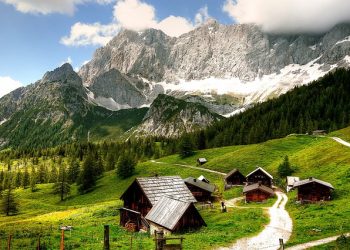
This is what the views along the trail look like
The trail is challenging and best suited for experienced hikers. It features 8 bridges, about 500 steps, and 2 ladders, including a 50-meter-long steel rope bridge over the canyon. After the canyon, the trail continues to the alpine lake Riesachsee.
The hike starts at the paid Seeleiten car park (1,025 m) with a steep ascent along the rushing stream, leading to the large rope bridge at the start of “Hell’s Canyon.” If desired, you can skip the canyon section and continue directly to the lake, which is recommended for small children.
Entering the canyon involves many stairs. The trail is well-maintained and safe, but caution is needed. You will be close to the rushing stream and can enjoy the scenery. To exit the canyon, climb a ladder to reach the Gfölleralm mountain hut, where you can rest, eat, and admire Riesachsee and the surrounding forested mountains. From there, it’s a short walk to the lake shore, with an optional 20-minute continuation to the Kaltenbachalm hut.
Return to the car park by following the path that goes through the forest, as returning through the canyon is not possible.
Additional Essential Information for Your Visit
- Difficulty Level: Medium (there are elevation differences of about 300 meters on the ascent and descent). The walk inside the canyon is not suitable for young children.
- Suitable Hiking Season: May – October.
- Opening Hours: The trail is open 24 hours a day. It is recommended to arrive only during daylight hours.
- Starting Point: Seeleiten Parkplatz (paid parking).
- End Point: The trail is circular, so you finish at the same car park where you started.
- Trail Length: 3.9 kilometers.
- Walking Duration: About 2 hours.
- Recommended Equipment: Shoes with good grip and as waterproof as possible. It is also advisable to bring waterproof and rainproof clothing, as it can be rainy even on warm summer days.
- Food and Drink: Equip yourselves with enough food and drink for the journey. Even if you plan to stop at one of the hiker’s huts along the trail, it is important to take into account that there is a walking distance to reach them.
Websites:
- Outdooractive trail portal
- Wild Waters trails website
- Information on the regional website of Schladming-Dachstein
If you are visiting the Schladming area, you can enjoy the best recommendations we have gathered for this region. In the dedicated article on the Schladming-Dachstein area, you can find additional attractions, accommodation recommendations, and a general explanation of the area.


