
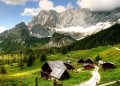
The city of Vienna offers visitors a wonderful combination of culture, art, and history. Another important aspect of the city, which too many visitors miss, is the impressive nature that surrounds it.
Within the city, there are well-maintained parks and many charming spots among lawns and trees, but the nature awaiting those who venture out of the city center is much more beautiful. Even if you travel to the Linz Animal Park, you can already get a taste of the “wild” nature of the Vienna area.
Where are the Hiking Trails in Vienna’s Nature?
Around the city is the Vienna Woods (Wiener Wald), which spans a huge area and is partly within the city limits to the east. Within the forest, there are many hiking trails as well as mountain biking trails. Besides the Vienna Woods, there are also nature reserves to the west with a variety of marked hiking trails.
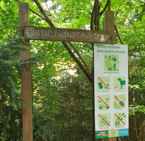
11 selected trails out of the many are called “City Hiking Trails” (Stadtwanderweg). These trails were chosen by the Vienna Forestry Department and are considered easy and suitable for hikers of all ages.
These trails are circular and well-marked. Along them, there are nice attractions for children, inns for lunch or a cold beer, and picnic spots in nature.
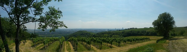
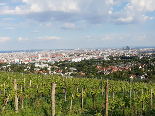
Some of the trails will lead you to the top of the hills surrounding the city, such as Kahlenberg or Wilhelminenberg, from where you can view the entire city and admire the wonderful scenery. Also, in these areas, there are usually well-tended vineyards and wine taverns (Heurigen) with excellent wines and authentic local food. Please note that some of the trails require a certain level of physical fitness, and some have rather challenging ascents.
We have compiled for you the 11 city hiking trails. The trails are arranged according to their actual numbering on site. You can navigate between the trails by clicking on the links in the table of contents below:
- Hiking Trail No. 1 – Kahlenberg – Recommended
- Hiking Trail No. 1a – Leopoldsberg
- Hiking Trail No. 2 – Hermannskogel
- Hiking Trail No. 3 – Hameau
- Hiking Trail No. 4 – Jubiläumswarte (Observation Tower) – Recommended
- Hiking Trail No. 4a – Ottakring
- Hiking Trail No. 5 – Bisamberg – Recommended
- Hiking Trail No. 6 – Zugberg-Maurer Wald
- Hiking Trail No. 7 – Laaer Berg
- Hiking Trail No. 8 – Sofienalpe – Recommended
- Hiking Trail No. 9 – Prater – Recommended for families
Hiking Trail No. 1 – Kahlenberg
Kahlenberg is Vienna’s famous mountain, offering views of the entire city. The hiking trail to the top of the mountain (don’t worry, it’s more like a hill) passes through vineyards, fields, and wooded areas. When you reach the summit, you can enjoy several fun attractions and authentic wine taverns. You can read more in the extended article we prepared about Kahlenberg.
The hiking trail starts from the last stop of tram line D. This is a circular route, so you will return to this station at the end. Line D passes through the heart of the city and stops at stations such as Karlsplatz, Schottentor, and the City Hall.
- Trail Length: 11 kilometers
- Walking Duration: 3.5 to 4 hours
- Difficulty Level: Easy – Moderate
The Route:
- The last stop of tram line D. Station name: Nußdorf
- Zahnradbahnstraße
- Beethovengang
- Wildgrubgasse
- Wildgrube
- Sulzwiese
- Höhenstraße
- Sender Kahlenberg
- Josefinenhütte
- Eiserne Hand
- Eisernenhandgasse
- Kahlenberger Straße
- Eichelhofweg
- Eichelhofstraße
- Nußberggasse
- Bockkellergasse
- The last stop of line D
Check out the map of the stops on the Vienna City website.
Hiking Trail No. 1a – Leopoldsberg
This trail also passes through the Kahlenberg area. Along the way, you can enjoy views of the Danube River and beautiful green vegetation.
The trail starts and ends at the Nußdorfer Platz station. To reach the starting point, take tram line D. Line D passes through the heart of the city and stops at stations such as Karlsplatz, Schottentor, and the City Hall.
- Trail Length: 11 kilometers
- Walking Duration: 3 to 4 hours
- Difficulty Level: Easy-Moderate
The Route:
- Nußdorfer Platz
- Donaustrandpromenade
- Kahlenbergerdorf
- Nasenweg
- Leopoldsberg
- Höhenstraße towards Kahlenberg
- Kahlenberger Straße
- Eichelhofweg
- The path towards Waldbachsteig
- Kahlenbergerdorf
- Donaustrandpromenade
- Nußdorfer Platz
Check out the map of the stops on the Vienna City website.
Hiking Trail No. 2 – Hermannskogel
This trail is located west of the Kahlenberg area, and halfway through, you will walk right on the city border with Lower Austria. Along the way, there are several wine taverns and inns where you can sit, rest, and enjoy delicious Austrian food (Häuserl am Stoan is recommended).
The trail starts from the last stop of bus line 39A – Sievering station.
- Trail Length: 10 kilometers
- Walking Duration: 3 to 4 hours
- Difficulty Level: Easy-Moderate
The Route:
- Sievering station
- Agnesgasse
- Salmannsdorfer Höhe
- Häuserl am Stoan
- Grüass-di-a-Gott-Wirt
- Hermannskogel (542 meters high). Here you can see an ancient observation tower from the Habsburg Empire era.
- Jägerwiese
- Bei der Kreuzeiche
- Cobenzl
- Am Himmel
- Gspöttgraben
- Sieveringer Straße
- Sievering station
Check out the map of the stops on the Vienna City website.
Hiking Trail No. 3 – Hameau
An enjoyable walk deep in the Vienna Woods. This trail is also located in the northern part of the city. It passes through forest areas towards the wooded Hameau peak. Along the way, you can stop at the Zur Allee restaurant.
The trail starts at the final stop of tram line 43. The station is called Neuwaldegg. Tram 43 departs from Schottentor station.
- Trail Length: 10.5 kilometers
- Walking Duration: 3 to 4 hours
- Difficulty Level: Moderate
The Route:
- Neuwaldegg
- Dornbacher Straße
- Waldegghofgasse
- Schwarzenbergallee
- Schwarzenbergpark
- Hameauweg
- Hameau
- Dreimarkstein
- Waldrandweg
- Kleeblattweg
- Keylwerthgasse
- Michaeler Wald
- Geroldgasse
- Schwarzenbergallee
- Neuwaldegg
Check out the map of the stops on the Vienna City website.
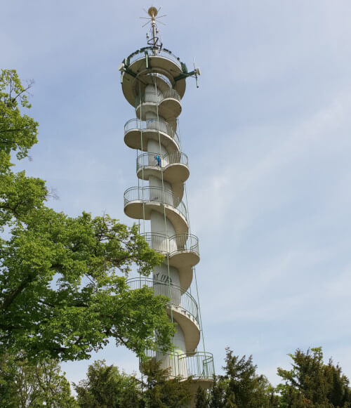
Hiking Trail No. 4 – Jubiläumswarte (Observation Tower)
This trail passes through dense forests towards the observation point from which you can see magnificent views of the entire area. On clear and beautiful days, you can see as far as Schneeberg mountain. If you prefer to skip the walk and just visit the observation tower, you can take bus line 52B which stops nearby.
The trail starts from the Bahnhofstraße station. To reach this station, take tram line 49. This line passes through central stations such as Volkstheater and Westbahnhof. Click to view the stops of this line.
- Trail Length: 7.2 kilometers
- Walking Duration: 2.5 to 3 hours
- Difficulty Level: Moderate
The Route:
- Bahnhofstraße
- Dehnegasse
- Dehnepark
- Silberteich (a small, hidden lake in the heart of the forest)
- Steinböckengasse
- Satzberg
- Wickengasse
- Seglerweg
- Jubiläumswarte (a free observation tower with views of the entire area).
- Kreuzeichenwiese
- Steinbruchwiese
- Loiblstraße
- Kleibersteig
- Rosental
- Dehnepark
- Bahnhofstraße
Check out the map of the stops on the Vienna City website.
Hiking Trail No. 4a – Ottakring
This trail is easily accessible and starts from the Ottakring subway station. From there, a short walk leads to the Vienna Woods. In this area, there are a variety of beautiful vineyards, a luxurious hotel, and a magnificent viewpoint over the entire city.
The starting point of the trail, as mentioned, is the last stop of subway line U3. This station is called Ottakring.
- Trail Length: 10 kilometers
- Walking Duration: 2.5 to 3 hours
- Difficulty Level: Mostly easy. Some sections require a moderate uphill walk.
The Route:
- Ottakring
- Thaliastraße
- Gallitzinstraße
- Funkengerngasse
- Rolandweg
- Johann-Staud-Straße
- Pelzer Rennweg
- Andergasse
- Eselstiege
- Savojenstrasse
- Sprengersteig
- Paulinensteig
- Wilhelminenstraße (In this area there is a luxurious hotel called Schloss Wilhelminenberg with a restaurant and a wonderful view of the entire city.)
- Kollburggasse
- Erdbrustgasse
- Ottakringer Straße
- Weinheimergasse
- Ottakring
Check out the map of the stops on the Vienna City website.
Hiking Trail No. 5 – Bisamberg
On this trail, you walk from the village of Stammersdorf, which was annexed to Vienna, to the peak of Bisamberg. In the Bisamberg area, there is a huge amusement park for children that is worth visiting.
The trail starts from the last stop of tram line 31. The station is called Stammersdorf. This tram starts from Schottentor station. Click to view the stops of this line.
- Trail Length: 10.3 kilometers
- Walking Duration: 3 to 4 hours
- Difficulty Level: Easy – Moderate
The Route:
- Stammersdorf
- Josef-Flandorfer-Straße
- Luckenschwemmgasse
- Liebleitnergasse
- Clessgasse
- Neusatzgasse
- Steinernes Kreuz
- Parkplatz Hagenbrunnerstrasse
- Senderstraße
- Unterer Senderrundweg
- Magdalenenhof
- Eichendorffhöhe
- Promenadeweg Falkenberg
- Herrenholz
- Schießstätten
- Luckenholzgasse
- Clessgasse
- Stammersdorf
Check out the map of the stops on the Vienna City website.
Hiking Trail No. 6 – Zugberg-Maurer Wald
This trail starts in southwestern Vienna and partly extends beyond the city limits into the forest of Lower Austria. It is a comprehensive and fairly simple trail. Along its length, there are several attractions, the most recommended of which is called Pappelteich. This is a small pond with many varieties of frogs. This pond is actually a small nature reserve and an educational and fun place for children.
The starting point of the trail is the final stop of tram line 60. This station is called Rodaun. This line starts from Westbahnhof station. It also stops at the U4 station called Hietzing.
- Trail Length: 12.5 kilometers
- Walking Duration: 4 to 4.5 hours
- Difficulty Level: The trail is easy, but requires a lot of walking.
The Route:
- Rodaun
- Ketzergasse
- Willergasse
- Rodauner Kirche
- Zugberg
- Wiener Hütte (A great place for an authentic lunch in the heart of green fields and wooded hills).
- Roter Stadl
- Continue through Eichwiese clearing and Gütenbachtal valley
- Jägerhaus
- Antonshöhe
- Schießstätte (Here you can cut towards tram line 60).
- Georgenberg
- Pappelteich (the frog pond)
- Kalksburger Straße
- In der Klausen
- Kalksburg
- Mackgasse
- Promenadeweg
- Ketzergasse
- Rodaun
Check out the map of the stops on the Vienna City website.
Hiking Trail No. 7 – Laaer Berg
This trail passes through the southern part of the city and encompasses beautiful areas such as the well-kept park of the Vienna Spa in Oberlaa neighborhood or the ancient amusement park of the 10th district. Part of the trail passes through Laaerwald forest.
The trail starts from the U1 subway station which is located near the Vienna Spa. This station is called Altes Landgut.
- Trail Length: 15 kilometers
- Walking Duration: 4 to 5 hours
- Difficulty Level: Easy – Moderate
The Route:
- Altes Landgut
- Horrstadion
- Theodor-Sickel-Straße
- Laaer-Bergstrasse
- Urselbrunnengasse
- Laaerwald
- Böhmischer Prater (similar to the large Prater park. Includes ancient amusement rides).
- Löwygrube
- Amarantgasse
- Goldberg
- Kurpark Oberlaa – The well-kept park of the Vienna Spa.
- Mittelweg
- Rotes Kreuz
- Unter-Laaer Straße
- Liesingpromenade
- Per-Albin-Hansson-Straße
- Holeyplatz
- Heuberggstätten
- Altes Landgut
Check out the map of the stops on the Vienna City website.
Hiking Trail No. 8 – Sofienalpe
To the northwest of the city, there is a wonderful natural area with open spaces of low vegetation and hills from which you can enjoy a wonderful view of the entire area.
The trail starts from the Kasgraben bus stop. You can reach it by bus number 450. You get to the bus from the final stop of the U4 subway line. The final stop is called Hütteldorf. The trail passes through the area where the unique Ernst Fuchs Museum is located.
- Trail Length: 11 kilometers
- Walking Duration: 3 to 4 hours
- Difficulty Level: Easy
The Route:
- Kasgraben
- Greutberg
- Mostalm
- Franz-Karl-Fernsicht
- Sofienalpe
- Abzweigung
- Kolbeterberg
- Laudon-Grab
- Kasgraben
Check out the map of the stops on the Vienna City website.
Hiking Trail No. 9 – Prater
This hiking trail is especially suitable for families with children. It passes through the green Prater Park towards the Danube River. Along its length, there are several nice restaurants where you can stop and refresh yourself (Schutzhaus Wasserwiese is recommended).
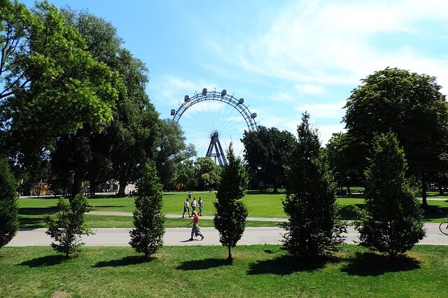
The trail starts from the central Praterstern station. Subway lines U1 and U2 intersect at this station. From the station, walk directly into Prater Park and then continue along the trail’s signage.
- Trail Length: 13 kilometers
- Walking Duration: 3 to 4 hours
- Difficulty Level: Easy
The Route:
- Praterstern
- Hauptallee
- Rustenschacherallee
- Stadionallee
- Wasserwiese
- Lusthaus
- Poloweg
- Krebsenwasser
- Hauptallee
- Oberes Heustadl-Wasser
- Liliputbahn
- Konstantinhügel
- Praterstern
Check out the map of the stops on the Vienna City website.
There is no doubt that these trails will expose you to the wonderful nature of Vienna and its hidden gems that are not crowded with tourists.


