
The Gailtal is a large, wide valley that actually begins in East Tyrol and ends in the Villach area of Carinthia. The Gail River flows along the valley, giving the valley its name. Along the valley are scattered high mountain peaks; to the north are the Dolomites and the Alps, and to the south is the Karawanken mountain range. Some of the peaks are accessible by cable cars and offer skiing in winter and beautiful hiking trails in summer.
The main towns in the Gailtal are Hermagor and Nassfeld. Near these towns, there is a small lake called Pressegger See, which is a major attraction for travelers, mainly because of the variety of water activities it offers. Near the lake, there is also a small park with inflatable facilities for children, trampolines, a playground, and more.
In Nassfeld, there is a ski resort with slopes that are particularly suitable for families with children. The slopes are relatively simple and suitable for those who want to practice skiing or snowboarding.
Aqua Trail
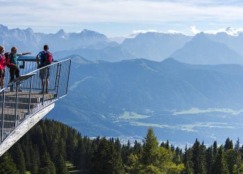
In the summer, you can go on an enjoyable hiking trail following the many waters flowing in the area. This trail is called the Aqua Trail and is located at the top of the mountain near Nassfeld. The trail is 1.5 kilometers long and presents information about the world of water in the heart of the mountains, the construction of dams in the high lakes, and more. As part of the trail, there are playgrounds for children and also a small lake where you can swim.
This is what the trail looks like
Please note: To reach this trail, you must take a cable car to the top of the mountain. The trail paths are spacious and also suitable for strollers.
Address: Sonnenalpe Nassfeld 114, 9620 Sonnenalpe Nassfeld
Garnitzenklamm Canyon in the Heart of the Gailtal
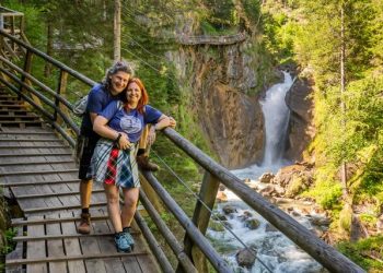
Rocky passages stretching many kilometers characterize the southern Gailtal, where the impressive Garnitzenklamm canyon cuts through the landscape. This canyon is only 2.5 kilometers south of the town of Hermagor. The canyon trail stretches 4 kilometers along a path carved by powerful glacial meltwater at the end of the last ice age
The lower part of the canyon was opened to hikers as early as 1891 but was closed several times due to floods that destroyed the bridges built in it. In general, the place is prone to floods, so you must obey the safety instructions and the guidelines of the team that supervises the trail.
The walk inside the canyon is a constant ascent among rocks and gravel paths, so it is defined as being of moderate difficulty.
There are several recommended hiking trails within the canyon:
- Trail 1: From the beginning of the trail in the canyon, walk through sections 1 and 2 and from there, turn via the stone path to trail number 410. From this section, you begin the descent towards the village of Möderndorf. The walk takes about two hours.
- Trail 2: From the entrance to the canyon, walk through sections 1, 2, and 3, and from there, turn via the path that goes through the forest to trail number 410, which will lead you to the village of Möderndorf. The walk takes about 4 hours.
- Trail 3: Walk through the canyon to its end and then return by one of the ways mentioned earlier. The walk through the canyon takes about two and a half hours, and the way back also takes about two and a half hours.
You can see the trails on the interactive map.
For those who want to try via ferrata climbing, there are several routes right at the beginning of the trail.
Trail Opening Times:
The trail inside the canyon is open from the end of May to the end of September. Please note: You can enter the canyon even after it closes, but walking in it is at your own risk.
Costs:
- Adult – €7
- Child up to age 14 – €3
Official Website
Address: Eggeralmstraße, 9620 Möderndorf
Map:


